Sea surface height contains valuable information about variations in Earth's gravity field, and higher resolution measurements of submesoscale sea surface height anomalies (SSHA) offer the potential for more precise detection of these gravitational changes. The next-generation interferometric altimetry satellite, Surface Water and Ocean Topography (SWOT), has for the first time provided humanity with the ability to observe SSHA.
Recently, the research team led by Prof. XU Yongsheng from the Institute of Oceanology of the Chinese Academy of Sciences (IOCAS) demonstrated that SWOT significantly enhances the resolution of gravity field inversion, showcasing its tremendous potential for revealing Earth's internal structure and its changes.
The study was published in IEEE Geoscience and Remote Sensing Letters on July 22.
On Earth, a still sea surface aligns with the equipotential surface of Earth's gravity field. Therefore, any factors that cause changes in the gravity field—such as seafloor topography (including seamounts and trenches), variations in water depth, changes in Earth's internal structure (such as mantle convection and plate movements), as well as underwater earthquakes and volcanic activity, can theoretically be inferred by accurately measuring changes in sea surface height.
However, since these factors only induce minute variations in Earth's gravity field, improving the resolution of altimetry satellites is crucial. By comparing SWOT data with shipborne gravity measurements, researchers confirmed that SWOT excels in resolving small-scale gravity field variations, outperforming traditional radar altimeters. "This finding suggests that SWOT will pave the way for significant scientific breakthroughs in our understanding of the deep ocean," said Prof. XU, corresponding author of the study.
Satellite altimeters typically orbit about 1,000 kilometers above the sea surface, making enhancing the resolution of sea surface height observation the biggest challenge. Traditional radar altimetry satellites not only have low resolution but also are limited to one-dimensional height measurements along their orbit, severely restricting their gravity field inversion capabilities.
SWOT overcomes these limitations by innovatively applying interferometric technology—commonly used for probing the microscopic world—to space satellites, achieving wide-swath, three-dimensional, high-resolution measurements of sea surface height changes. Its resolution is an order of magnitude higher than that of traditional radar altimeters.
"The successful launch of the SWOT satellite holds tremendous significance both scientifically and practically, marking the beginning of a new era in ocean remote sensing," said Prof. XU.
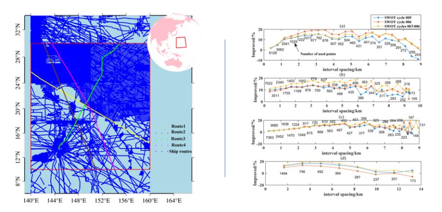
The left panel shows the region used for validating SWOT's gravity field inversion, including the comparison routes and shipborne gravity measurement trajectories. The right panel illustrates the accuracy improvements of SWOT gravity fields at various resolutions along different comparison routes.
Wang jianbo, Xu Yongsheng* et al. Improving High-Frequency Marine Gravity Anomaly Recovery: The Efficacy of SWOT Wide-Swath Altimetry. IEEE Geoscience and Remote Sensing Letters, vol. 21, pp. 1-5, 2024, Art no. 7505905, doi: 10.1109/LGRS.2024.3431694.
(Text by XU Yongsheng)
Media Contact:
ZHANG Yiyi
Institute of Oceanology
E-mail: zhangyiyi@qdio.ac.cn
(Editor: ZHANG Yiyi)